 In each “Sentry Story,” we’ll describe an actual flight and share the view out the window and ForeFlight screenshots. You’ll see how Sentry can be used to make flying safer and easier, plus you’ll learn some tips for flying with datalink weather. Want to share your story? Email ipad@sportys.com.
Learn more about the Sentry line of ADS-B Receivers:
Sentry Mini>>
Sentry>>
Sentry Plus>>
Sentry Story #2
Date: August 3, 2024
Aircraft: Piper Aztec
Route: I69 to KECP
Flight rules: IFR
Altitude: 9,000
Flying in and out of coastal airports in Florida presents unique weather challenges compared to flying in the Midwest. In my home state of Ohio, if there is no frontal activity or active low-pressure systems, thunderstorms typically don’t get going in the summer until the afternoon when the temperature and instability ramp up. However, all bets are off along the coast of Florida, where the tropical environment and abundant moisture favor convective development any time of day.
When flying out of the Midwest in the summer, I prefer an early start for several reasons: the air is smoother, the temperatures are cooler, and there are typically no storms to deal with.
On a recent flight from Cincinnati to Panama City, FL, however, leaving early wouldn’t guarantee a storm-free flight. While most of the 528 NM flight would consist of nothing more than a few stratus or cumulus clouds, there was an active weather system with lots of convection and heavy rainfall churning on all sides of the destination. Here’s what that looked like at 8 AM:
The current Panama City TAF included VCSH (showers in the vicinity) for the entire day. The narrative from the meteorologists in the textual Aviation Forecast Discussion talked about how a shortwave trough “could” lead to convection across the entire panhandle at any point over the next 24 hours. That’s about as vague of a forecast as you’ll find and doesn’t guarantee much about what the conditions would actually be like during the arrival.
If I had been briefing this flight 15 years ago, before the days of in-flight ADS-B datalink weather, I likely would have canceled the flight. The weather system was growing and strengthening in the early morning, and all the ingredients were there to cause it to persist throughout the day.
But for this flight, knowing I could keep an eye on updated radar imagery in flight to monitor the movement and trend, I felt comfortable giving it a shot. And a lot could change with this system over the three-and-a-half-hour flight, especially given the forecast uncertainty.
I had Plan B (Dothan, AL, 60 miles inland) and Plan C (Montgomery, AL, 120 miles inland) in mind as alternates, which were both forecast to be VFR and dry later that day. I also briefed my wife that we might be doing a little sightseeing in Alabama that afternoon if the weather in Panama City didn’t work out, and she was more than okay with that (my two-year-old son didn’t get a vote).
I took one final look at the internet radar on my iPhone before starting up, and while the system was still strengthening, it looked like it was picking up speed and moving faster to the southeast.
We departed IFR around 8:30 am and broke out on top of a solid overcast layer to enjoy plenty of scenic views as the sun rose to the east.
After leveling off at 8,000’, I opened ForeFlight on my iPad and connected to Sentry to view the latest radar update. It still looked rather ominous, but part of that was because it was displaying the “national” ADS-B radar feed, which uses low-resolution imagery when over 250 NM away. This exaggerates coverage and intensity but is still useful for monitoring motion and growth trends. 
We pressed on for the next 90 minutes, enjoying the smooth morning air, but soon fortune began to work in our favor. The system started dissipating rapidly, and as you can see in this screen recording below, the convection completely fizzled out.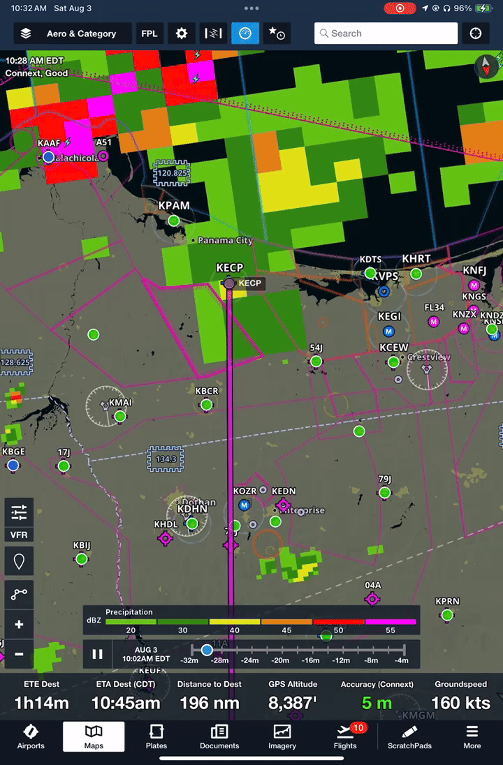
It’s also worth pointing out in this example that you can see how the lower-resolution national radar imagery transitioned to the higher-resolution regional radar when we were within 250 NM.
The rest of the flight was uneventful, and for the final 50 miles, we didn’t fly through a cloud or experience the slightest bit of turbulence. The only way you would have known that there were storms in that same airspace only a few hours ago was from the puddles on the FBO ramp.
Flying with Sentry and ForeFlight gave me the confidence to launch on a day with many uncertainties. If the storm system around Panama City had stuck around or gotten worse, the ADS-B weather feed from Sentry would have provided all the information I needed well in advance to make a plan to divert.
Fortunately, it didn’t come to that, and we enjoyed a spectacular sunset on the beach that night.
Want to share your story? Email ipad@sportys.com for a chance to be featured in one of our Sentry Stories.
Learn more
Read every edition of Sentry Stories here
Sentry line of ADS-B Receivers: